


The extremely low water levels of Lake Balaton, Lake Velence, and the Danube in 2026 have once again drawn attention to the vulnerability of the Carpathian Basin's water resources. The recently published study by ELTE researchers, examining the entire Holocene (the past 11,700 years) history of Lake Balaton, shows that the lake has previously endured prolonged, extremely dry periods, and also reveals what signs these left in the sediments.
On July 31, 2026, the average water level of Lake Balaton was 56 centimeters compared to the Siófok water gauge, which naturally does not denote the lake’s average depth. On the same day, the measurement at Lake Velence in Agárd was 32 centimeters, while the Danube in Budapest fell below its previous measurement record at the end of July.
Why is there so little water now?
The current situation is not the result of a single dry summer. On the catchment area of Lake Balaton, between 2021 and April 2026, almost 500 millimeters of cumulative precipitation deficit developed. The winter recharge period of 2025–2026 brought 26 percent less precipitation than average. On the catchment area of Lake Velence, the winter deficit was 37 percent, therefore the lake was unable to replenish even by the start of the evaporation period.

Atmospheric circulation plays an important role in the development of droughts. Persistent anticyclones and upper atmospheric ridges divert or weaken precipitation-bringing fronts. Descending air movement results in sunny, dry weather, while heat, sunlight, and wind intensify lake evaporation. Drying soils further boost warming: less energy is used for evaporation, and more is spent directly heating the surface and the air. Global warming isn’t solely responsible for every drought, but beginning from a higher temperature baseline, it increases the demand for evaporative water, making heatwaves more frequent, longer, and more intense.
What does the “climate archive” lying at the bottom of the lake reveal?
Staff at the ELTE Department of Environmental and Landscape Geography, Pannon University, and HUN-REN CSFK Institute of Geology and Geochemistry, under the leadership of Enikő Magyari, examined a sediment core taken from the Szemes Basin of Lake Balaton in a study published in Quaternary Science Reviews.
The researchers determined the ages of sediment layers using radiocarbon dating, then used several analytical methods to explore how the environment of Lake Balaton changed over the millennia. They examined the chemical composition of the sediments, the composition and structure of minerals, and the ratios of elements and isotopes within, which indicate the extent of evaporation and water level changes. They also analyzed, using modern microscopic methods, the structure of carbonate minerals that once formed in Balaton’s waters. Additionally, the grain size, organic content, and other properties of the sediments were examined, and geophysical measurements helped reconstruct past changes in the lake bed.
The unique approach utilized not only the chemical composition of the sediment, but also the crystal structure of previously precipitated magnesium-bearing calcite and protodolomite for reconstructing evaporation and water level changes (Figure 1).
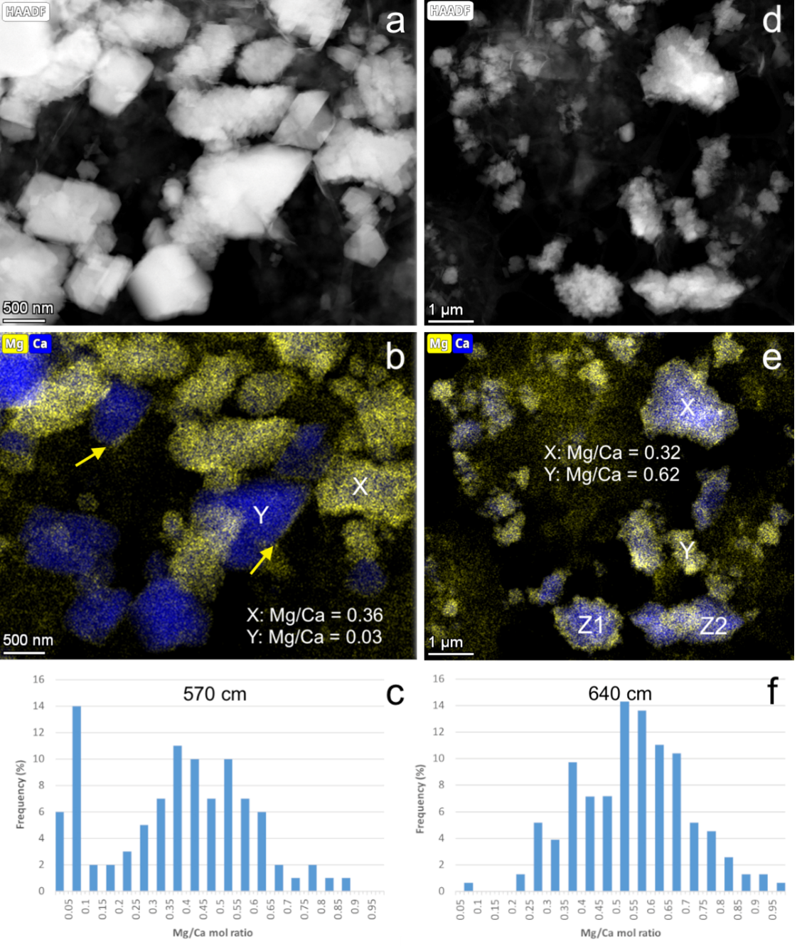
Figure 1. Nanometer structure of carbonate grains formed in Lake Balaton sediments. *
The driest period of Lake Balaton during the Holocene
The researchers identified two periods in Balaton’s history when evaporation was strong and water levels were sustainedly low: about 8050–7350 and 5450–4500 years ago. Of the two, the first was the driest in the past 11,000 years. Summers became hotter, while less moisture reached the region. Increased evaporation of the lake’s water is indicated by geochemical traces preserved in the sediments; additionally, drought-tolerant steppe vegetation spread locally.
Ancient water levels cannot be precisely expressed in the centimeters of today’s Siófok water gauge. However, according to bed morphology and paleoecological estimates, at the study site, water depth was only about 2.5–3.5 meters, compared to 4.2 meters in 2017. Allowing for the uncertainties of long-term bed change, this signals roughly 0.7–1.7 meters lower water surface. The area of deep open water contracted significantly and could have been mainly restricted to the Szemes Basin, though the lake did not completely dry out (Figure 2).
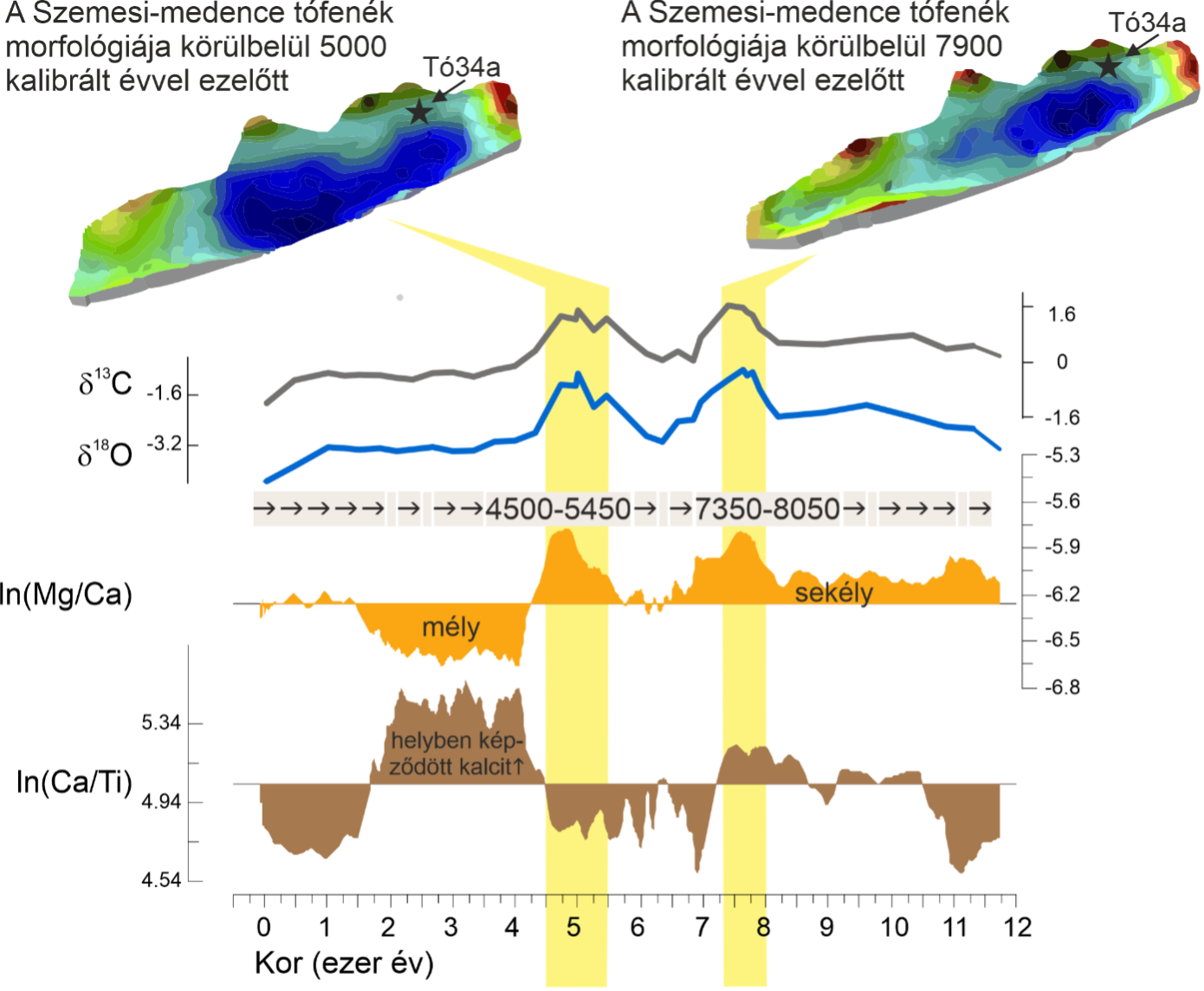
Figure 2: Main results of geophysical measurements and geochemical sediment analyses in the Szemes Basin of Lake Balaton.
Could Lake Balaton reach this level again?
Short-term predictions are impossible, and ancient and current water levels cannot be directly compared. However, the study based on 24 regional climate models by Márk Honti and colleagues shows that, without external water supplementation, extremely low water levels may become increasingly frequent during this century.

According to the most unfavorable climate scenarios, the decline in Lake Balaton’s water level could accelerate after 2050. Models suggest that extremely low water levels may become much more frequent by the end of the century. While these are not exact forecasts, they warn that in the absence of sustained warming and external water supply, Balaton could approach the conditions experienced during the great droughts thousands of years ago.
Why is it important to know past water levels?
Holocene history reveals the limits of Lake Balaton’s natural variability and helps distinguish natural fluctuations from the effects of human water management and accelerating warming. Studying past extremes helps identify those hydrological thresholds where the shoreline, carbonate formation, nutrient cycling, or the lake’s ecological functioning changes.
Research can be developed with additional sediment cores, denser radiocarbon dating, triple oxygen isotope analyses, fossil pigments, and sedimentary DNA. Linking paleoclimatic results with hydrological models may help ensure that decisions about water supplementation, water level regulation, and shoreline infrastructure transformation are made not just for the next dry year, but for the coming decades.
_________
* Figure 1: Transmission electron microscopy shows two layers of a sediment core from the Szemes Basin: a sample formed 5015 years ago from a depth of 570 centimeters (a–c), and a 7385-year-old sample from 640 centimeters (d–f). In images (a) and (d), the lighter areas indicate regions with more heavy elements. Diagrams (b) and (e) show how calcium and magnesium are distributed in carbonate grains. Yellow arrows indicate magnesium-rich grain areas. Samples marked X and Y also feature the magnesium-to-calcium ratio, while magnesium distribution differs in grains Z1 and Z2. Charts (c) and (f) illustrate the frequency of carbonate grains with varying magnesium content in the samples. The 7385-year-old layer generally contained more uniformly distributed magnesium, suggesting stronger evaporation and lower water level in Balaton at that time.
Figure 2: Preliminary height maps of two near-shore lake erosion surfaces, based on geochemical data, relate to periods characterized by strong evaporation and low water levels. One surface formed about 7900 and the other about 5000 calibrated years ago. The term “calibrated years before present” (cal yr BP) uses 1950 as the reference year. The periods of lowest water in the Szemes Basin are signaled by higher logarithmic Mg/Ca values and peaks in oxygen and carbon isotope ratios. Interestingly, the degree of erosion, indicated by increasing logarithmic calcium and titanium ratios depicted on the image (where the scale is reversed), was lower during low water periods.